01PC MONITOR
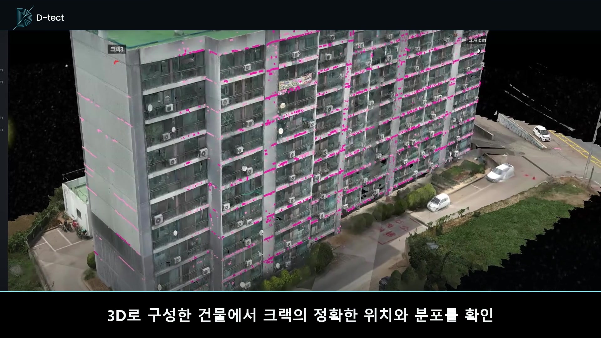
Naria Apartment Complex 13D crack location
Manage status and repair quantities

AI APARTMENT FACADE INSPECTION PLATFORM
From Drone capture and AI detection to 3D location and time-series management,D-TECT connects precise repair estimation in one platform.
STEP 01 · CAPTURE
High-resolution images of the complete building façade are captured faster and more accurately than manual inspection.
STEP 02 · DETECT
Hundreds of façade images are analyzed automatically to mark crack geometry and calculate length and width.
STEP 03 · LOCATE
Review crack geometry, exact position and building-wide distribution on a high-resolution 3D model.
STEP 04 · ACCESS
Review and share crack location, condition, repair quantities and reports anytime on mobile and desktop.
Manage status and repair quantities
Review and locate defects on site
Check results anywhere
STEP 05 · REPORT
Detected crack length, width and position are compiled into evidence for reports and repair quantity estimates.
Contact D-TECT ↗WHY D-TECT · PLATFORM BENEFITS
D-TECT connects façade capture, AI analysis, location verification and quantity estimation to reduce time, risk and uncertainty.
Drone capture and automated AI analysis streamline labor-intensive fieldwork.
Faster field inspectionHundreds of façade images are reviewed to the same standard to detect fine cracks.
Consistent detectionCracks are projected onto a 3D building to identify elevation, floor and shape.
3D location managementCrack length, width and distribution provide a reliable basis for scope and budget.
Length · width · areaWHO USES D-TECT · CUSTOMER VALUE
Each team can apply the same objective façade data to its own inspection, decision and repair workflow with greater speed and precision.
Run a facade condition survey across hundreds of images to one standard, streamlining field review, concrete defect location checks and reporting.
Review the facade safety condition and risk areas objectively, then support repair priorities, budgets and resident communication.
Use crack position, length, width and area data to improve project scope, estimates and repair quantities.
Standardize inspection data across buildings and manage risk areas and budget priorities with consistent evidence.
CORE TECHNOLOGY · D-TECT ENGINE
The D-TECT engine combines high-resolution imagery and spatial data to quantify crack position, length, width and repair quantities.
STEP 06 · TIME SERIES
Accumulate façade condition at every inspection, compare repair effects and new defects, and use the data to plan the next inspection and repair.
Save defect position and geometry as baseline data
Record repaired zones and completed condition
Compare with the baseline and isolate changed areas
FAQ · FREQUENTLY ASKED QUESTIONS
Find clear answers about field capture, AI analysis and the results delivered by D-TECT.
Contact D-TECT ↗It replaces rope access and boom lifts with a drone facade inspection. Drone capture, AI crack detection, 3D location review and repair quantity estimation run as one platform, so a facade safety survey leaves the same project data available in the field and the office.
High-resolution imagery is combined with capture metadata and capture spatial information to convert image measurements into real-world dimensions. Detailed calculations are handled inside the protected D-TECT engine.
Existing close-range façade images can be used when they meet requirements for file format, capture distance, resolution, overlap and location data. We review the source material first and confirm the applicable scope.
Timing depends on building size, number of blocks, capture scope and image volume. We provide a capture, analysis and reporting schedule after reviewing the site.
Deliverables include a web-based 3D viewer, crack location, length and width data, defect distribution, repair quantities and a report summarizing the key results.
We review flight restrictions, building spacing and nearby obstacles in advance, then adjust the capture scope or recommend an alternative method when needed.